
I have been blessed with sunshine and hot weather for weeks and without really realising it, I had gained a fair amount of elevation and this combined with leaving at 7am meant it was cold. I soon stopped and changed gloves for a thicker pair and I found myself riding through low cloud along Highway 16 in the Bighorn National Forest. I even turned on my heated grips.
I had been riding about half an hour and I realised I was low on fuel. Normally, I would check on my GPS / Sat Nav how far it was to the next gas station, but as my unit was smashed from meeting the road at a high speed, I couldn’t do that, so I stopped to check my map and saw just a few small towns along the road. Should I waste time, turn around and go back to where I knew there was fuel? No, of course not! I was pretty angry with myself for being foolish enough not to think of filling up sooner, so I pressed on, watching my fuel gauge carefully.
The road between Buffalo and Worland is perhaps the most varied I have seen. It rises and falls, is straight is parts and twisty in others, the temperature changes dramatically with the elevation, parts are in forest and parts are on open high-plains. In only 84 miles between the two cities, there is much to see in this varying landscape. This is one of the pictures I took along this road....

This is a short video of the high plains scenery. I stood there imagining the settlers riding their wagons across here. Those must have been very tough times....
Soon I arrived at an unexpected pleasure. The long days of research before I left the UK meant I knew most of the things I would see along the road, but I had not heard of Ten Sleep Canyon until I was riding through it....


It was still early in the morning and I was now seriously low on fuel. The low fuel warning light had been illuminated for about 15 miles so I was REALLY low. To save fuel I killed the engine and coasted downhill through the canyon and that was exhilarating. There was no noise except my tyres on the road and the wind rushing by at 30 to 50 mph. I stopped to take some pictures, but I was cold that I really couldn’t be bothered to get my big camera out so I just took a few quick shots with my point-and-shoot camera. That was a mistake as the lens on that camera isn’t wide enough to capture everything I saw before me. It was much nicer than my feeble pictures portray.
Soon I reached the town of Ten Sleep and thankfully a gas station! I have never been so relieved to see one. I do carry a spare gallon of gas in my saddlebags, so I probably would have been ok, but it taught me a lesson to be more careful – sometimes the gas stations are a long way apart in the mid-west.
I carried on west and then in Worland headed north on some back roads. I saw the aftermath of another bad motorbike accident with a badly smashed Gold Wing lying in the road. I had passed the ambulance on the road a few minutes previously as it furiously wailed its way back towards Worland. That put me in a bad mood as I contemplated once again just what a risk riding a motorbike can be if you are not really careful.
Soon after reaching Greybull and eating some waist-expanding pancakes, I headed northwest on US 14 which is also known as the Big Horn Scenic Byway, and oh boy, does it live up to its name! This is approaching the Big Horn Mountains....

One part of the Big Horn Scenic Byway is Shell Canyon and this is exceptional, so I fixed on one of my Go-Pro cameras and made a video. What a great road....
Soon after, I arrived at Shell Falls....


This is looking back down Shell Canyon....

This wonderful road then carries on north over Granite Pass (9033 feet) and on the descent, I rode around one bend to find a bull standing in the middle of the road. There had been signs warning of the possibility of stock on the road for some time, so it wasn’t altogether a surprise, but I was unsure of what to do next. If it had been a cow, I would have just gone around it, but a bull? As he didn’t seem in any particular hurry (ie he didn’t move at all) I decided I had to ride around him anyway and thankfully he still didn’t move. In the contest of a big bull vs a big Harley, I am not sure who would win. I am glad I didn’t need to find out.
I arrived at my overnight stop, the Bear Lodge Resort at Burgess Junction in the Big Horn Mountains. The resort is at 2456m or 8057 feet above sea level and unsurprisingly does not have cell phone coverage. Whenever I arrive at where I am staying for the night I telephone my wife, but today I couldn’t do that. Knowing she would worry if I didn’t call, I decided to ride west until I found a signal. That turned out to be in Lovell, some 53 miles away!
On the way to Lovell, the elevation rose slightly to 9430 feet before dropping quickly down the mountain road. I stopped at the observation point for a few photos ....
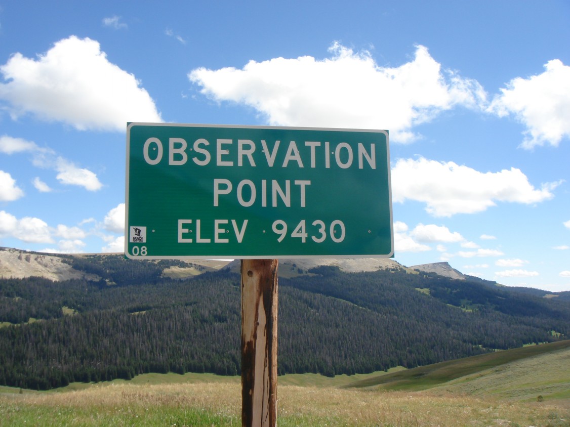
It wasn’t a very clear day, so the picture of the view wasn’t great.....

I turned around and noticed the last remnants of snow on the side of the mountain....

I looked at the temperature as I left the observation point. It was 64F (18C) at the top and just 18 minutes later when I reached the bottom of the mountain it was 82F (28C), a rise of 18F (10C) in just 18minutes. I soon took off my thick riding gloves and put on my thinner summer gloves!
As I rode towards Lovell and the meeting with a cell phone signal, I rode over the Big Horn River which is quite wide at this point....

I arrived in Lovell and filled up with fuel, telephoned Jackie and then rode the 53 miles back again! A 106 mile round trip for a phone call! It was worth it though as I got to talk to my wife. I try to remember to tell her all of the things I see each day, but sometimes I forget some! She then sometimes get a surprise when she reads my blog and see’s what I forgot to tell her about.....
I had noticed that my rear tyre (US=tire) was getting worn. I had stopped previously at the Harley Dealership in Gillette (probably the best and cleanest workshop I have ever seen), but it was late and they didn’t have the white-wall tyre I needed. They were very kind and telephoned around for me to locate one, which was in Billings, Montana. Day 55 therefore saw me making an un-planned ride to Billings which turned out to have an un-expected benefit.
Being aware that this was the Monday after the end of the Sturgis bike rally I had guessed any H-D dealer around here would be busy. I had checked on the phone and knowing this dealer operated a first-come-first-served basis, I knew I had to get there early. I woke at 5am and left at 5.30am in the dark. It was 160 miles to Billings so I was on a mission to get there as quickly as I could. Starting at over 8000feet up in the mountains at 5.30 in the morning means two things. It is very cold (40F / 4C) and you cannot see anything in the dark to either side of your headlight beam. Harley headlights are not great so I took it easy riding down the mountain, which in the dark, in a section of road construction is, well, let’s call it challenging! I passed the outline of a cow standing at the side of the road which made me slow down a bit....
It was a tough ride and I had to stop for coffee to try to warm up a bit. It was nice when the sun came up and the air began to get just a bit warmer.
Sunrise....

The first light of the day....

Long shadows on the road....

I arrived in Billings at 8.15 to find two people already there ahead of me. The place didn’t open until nine, so we chatted a while and compared road stories. Luckily (for me) the two people in front of me had more serious problems that needed an experienced mechanic whilst I just needed someone to change a tyre, so my bike was done quickly and by 10.30 ish I was on my way back to the Big Horn Mountains.
On the way to Billings, I had seen a sign for the Battleground of the Little Big Horn. I can remember learning a little about Custer, the Red Indians (as I called them when I was a child), and the massacre at the Little Big Horn, so I went to take a look. This is where General Custer and a few hundred soldiers lost a battle against a few thousand Sioux, Cheyenne and Arapaho Indians. He famously took his soldiers into this battle expecting the Indians to flee, but they didn’t and most of the soldiers, including Custer himself, where brutally killed. The Indians won this battle but later lost the war against their way of life and losing their land. I watched a short film and listened to an excellent talk by one of the Park Rangers about what happened here.
In the movies I watched as a young boy about the “Cowboys and Indians” I took the side of the Cowboys as the Indians were always portrayed as “the baddies”. I now know I had this the wrong way around and the Indians were simply trying to protect their land and way of life. Sure, they did some brutal things, but this was a war, a brutal things happen in war. The white man was the aggressor and I wonder today how the relationship between the “Native Americans” and the White Americans will ever be patched up. I have been though a few reservations on this trip and I have talked to a few Native Indians and there is still a lot of resentment between the two groups, even today. Clearly, there is much poverty on the reservations and whatever the rights and wrongs about why this is, it cannot be right. No doubt many have tried to put this right and have failed. As an outsider, I do not know the current day facts as to why this has happened, but I am sorry it has.
A few photos from my visit to the battlefield....
Looking up at where Custer and his men fought their last stand....

The white markers show where Custer and his men fell and were initially buried....


The red markers show where the Indians fell. There are a lot fewer of these....

Two of the memorial stones....


I liked this metal statue. It is part of the Indian Memorial....

I learned many things while I was at the Battlefield. The most surprising and shocking of which was there used to be 6o million Buffalo in North America....


.jpg)


11 comments:
Freakin' amazing! Love the videos. Just got back from a week ride and now I want to get back out again! Thanks alot dude.
How does it feel to be a cowboy? Now, I have to go and catch up on your other posts.
Gary, you are a master of the bike ride narrative.
I live in a small AZ town bordered on two sides by Indian reservations. Occasionally I spot a bumper sticker on a Native American owned vehicle that says simply "Custer had it coming." It's hard to dispute that for so many reasons.
Glad you didn't run out of gas Gary. I think you will be seeing some more very beautiful sights to come. It's funny because until I got to know two of my blog friends from England I didn't realize just how small England is, so this must just be amazing for you to travel so far and still be in the same country. (not that you didn't know, but the vast expanse of land it quite spectacular along with how much of it is uninhabited).
I'm learning about our early history each evening at 4 Central on FNC. The fellow was just talking about the relationship between our founders and the Native Americans when a storm came through and took out my signal...going to have to go on line and finish up the story. Not only the relationship but history that was covered up about the Indians for political reasons. It's eye opening.
Good riding today Gary. Hope you don't see any more accidents along your route.
Gary, as usual another mesmerizing re-count of your adventures! I'm tweeting your blog addy...because to speak the truth...more Americans should read what our country looks at through your eyes. It's all fresh and new again. Thanks.
WOW! What a breathtaking way to explore this beautiful planet. Your bikes are amazing and your journey spectacular.
Glad we stumbled across your blog this morning. We very much look forward to following your adventures.
Well wishes,
The Freely Living Life Family
Gary,
So fun to read about you and the Big Horn mountains. Stu & I rode it in the opposite direction, Gillette to Sheridan through the mountains to Ten Sleep and Buffalo. Brought back some great memories. Our photos are here: http://froggi.smugmug.com/2008-Motorcycle-Rides/Bighorn-Mountain-Motorcycle/5505007_cfDR4
BTW, this was when we first met!!
Glad you got your tire replaced okay...keep enjoying the ride!
Gary: It has been nearly fifty years since I visited Little Big Horn. Two things came to mind. First, when I visited there wasn't much around to explain what had happened. All of our National Parks and Historical sites have gotten more sophisticated. Then, there were a few plaques here and there and that was about it. And the second thought was, "I bet the meaning narrative has changed." I'm glad that there is both a more evolved interpretive center there and that the narrative being presented has more complexity than it once did.
~Keith
I am totally enjoying seeing my country through your eyes. Sadly, most of us tend to make travels just a point A to point B lazer trip. I joined you late but will catch up on your past posts. You hold my interest through out and have peaked my interest in taking off on a 4 wheel adventure. Gave up my bike last year due to age (not the bike, mine)
You are a very talented narrator. Thank you.
Gary:
We have the same problem up here with the First Nations People. They were here first and we took away their land and pushed them onto reservations. Even now it is hard for them to find jobs and they are taxing the social service system .
WOW, 106 miles for a telephone call. You should have purchased a SPOT Locator instead. I think you can also send messages with it using satellite and all of us could have followed your route on our computer.
I wonder what Ten Sleep stood for. If you are going to stay in the area for any length of time I would advise leaving after NINE sleeps, just in case
bob
Wet Coast Scootin
Bob, from Wikipedia, "Ten Sleep was an American Indian rest stop, so called because it was 10 days travel, or “10 sleeps,” from Fort Laramie (southeast), Yellowstone National Park (west-northwest), and the Indian Agency on the Stillwater River in Montana (northwest)."
Dave – Amazing yes! I am seeing some fantastic sights and am pleased that I am able to share what I see. I am a cowboy on one of those iron horses! Sorry I made you want to ride again, no wait a second, that should be a good thing!
Doug – Thank you. Before this ride, the only things I have written have been technical stuff relating to work, never anything creative, so I had my doubts if I was able to write anything that anyone would want to read. I like it when people say nice things like that! I would have to agree with you about the bumper stickers.
Eve – The UK is very small. Collectively England, Scotland, Wales and Northern Ireland are about the same size as Michigan, but with 62 million people living there. On its own, England is about the same size as Louisiana, or put another way, 31 of the states in the US are each bigger than England! I think that has been the one thing that has struck me more than anything – the sheer size of the US and just how much land there is per person.
Chessie – Thank you. I am wondering what I should do with my blog when I get back to the UK. Maybe turn it into a book? I am very lucky that I am able to see so much of this wonderful country!
The Freely Living Life Family – I am pleased you found my blog. It really is a great way to see the country. Stop, go, stay, talk, photograph, smell, touch whenever I want! That is the great thing about doing it on a motorbike rather than surrounded by the metal and glass of a vehicle. Doing it from an RV comes pretty close, especially a just cleaned one!
Donna – I love your pictures from the Big Horn mountains and I recognised so much from them! What a cool place for the two of you to meet.
Circle Blue – The information available at most of the National Parks I have seen so far has been impressive. The good thing is, there is just the amount of information you need – not too much and not too little, so clearly a lot of care has been put into them. I wish we had something like them in Europe, but we are still at the few plaques here and there stage!
Patti – I am thoroughly enjoying both seeing your country and sharing what I see through my blog. I am exceedingly lucky that I can do the journey at pace that means I can take as much time as I like. I am getting very good at doing U-turns and going back to investigate something that interests me! Thank you for your kind words and I hope you continue to look at my blog sometimes.
Bob – It is indeed a problem, but I wonder how, if ever, it will be solved. It is very sad. I heard about a Spot locator after I started my tour and I wondered about getting one. I can see that some people might see them as a safety device. If I was doing the tour again, I think I would get one, but there is a drawback – if anybody wanted to find you for malicious purposes they could. I looked at someone else’s on the web and I could tell which parking space their bike was parked in at that moment outside a motel. A case of giving out too much information I think!
Donna – You are absolutely right. I learnt that when I was there and I meant to write about it, but forgot. Thanks for investigating and helping Bob (generally he is very good at these things, but sometimes he needs a little help).
Post a Comment